Monday, January 30, 2012

Donnellson  . . . . 

January 29, 2012 is the end of four weeks of walking.  We're making good progress and the pacer mileage for the week claims we should be at 26.5 miles from our start point.  We are doing really well in that regard with most everyone in double digits this week!  Hooray! You guys are awesome!  Week three was really cold out and made me want to sit on the couch. Even though I am walking inside on a treadmill. Thank you all for helping with the motivation!  I know I have to walk or get left behind and that helps get me moving.  Today, it was 65 degrees outside in Central Iowa so we have NO EXCUSES!  Keep up the great momentum!

photo from the city of Donnellson, IA website cited on page
Walking this week puts us into the town of Donnellson in central Lee County. It's quite a small town, and from the satellite images, I think the Casey's (where I wanted Mike to buy pizza) has indeed closed.  That's sad, I wonder if it moved up onto the bypass.


In any case, I discovered that Donnellson, though small, has a great PR machine working for it.  The city website, http://www.donnellsoniowa.com/About/, calls the burg the heart of Lee County. Since, it is really in the center of the county, I'll give them some credit for that statement.  The site lists quite a lot of things to do through the year, including music concerts under the water tower, an Easter egg hunt, a Pumpkin patch, a July 4th parade, September's Apple Daze festival, the Lee County Fair, and races at the speedways. For a delightful brush with small town culture, check out the FAQ page off the city site. It reminds you that trash pickup is on Tuesday, you can burn leaves but not trash, reminds you there are congregate meals for seniors at the United Methodist Church, provides a phone number for the post office and says if you need to get into the city dump for unloading tree limbs or brush "Keys are available from City Hall, Russell and Gene, Chief Brandon Fowler and Mayor Bill Young." I miss small town life sometimes . .  There is a town newspaper and motel and you can rent the Westview picnic shelter by calling Michele B. I'm sure Stephen Bloom would be bored out of his mind and probably horrified  by the stock car races at the speedway, but I always had a good time at the Lee County fair and darn it, these people sound pretty darn NICE to me.


And now a history geek moment . . . According to the city web site's history page,  "The town of Donnellson was named for the Donnell families, W. A. and Eston, (brothers) who lived on either side of what is now Highway 218 in the south part of town . . . W. R. Donnell, a son of Eston, helped with construction of the first building in Donnellson. The building was a small warehouse used for a depot and storage purposes. This was the site where the first dance in Donnellson was held, on July 4, 1870. W. R. Donnell also was the first railroad agent, first express agent, the first merchant, and the first postmaster, holding these positions all at once.  In 1871, Donnellson started to grow when it was selected as a site for the railroad to travel through the area running from Fort Madison to Farmington . . . The Lee County Fair, “Iowa’s Oldest Fair,” was incorporated in 1878. . . 
http://www.donnellsoniowa.com/About/History.html

By 1881, Donnellson had three hotels, a hardware store, boot shop, post office, flooring mill, drug store, grain elevator, shoemakers, blacksmiths, harness maker, stockyards and an ice skating rink . . . On September 27, 1892, there was a petition filed with the Clerk of District Court requesting Donnellson to be an incorporated town. Donnellson was 120 acres with an estimated population of two hundred inhabitants . . . In 1895, Donnellson was dimly illuminated by four gasoline streetlights until August 1897. . . Donnellson was growing faster than any other town in the county in the early 1900’s. The town had the first telephone switchboard in 1900, a medical doctor and a cheese factory. There was an electric light plant by 1910, a water system & new dentist by 1912 and a veterinarian by 1913."

Today Donnellson is small indeed, but still on the map. It is at the crossroads of Highway 218 and state highway 2. Highway 2 is the Mormon Pioneer Trail memorial route and a great drive for site seeing. It leads up through Shimek State Forrest (great hiking and cross country skiing, wild turkeys, and such) and eventually into Van Buren County.  Great day long road trip, I recommend it whenever you have the chance. But today, we are still heading north into town.  The Casey's may be gone, but there is still a BP station on the corner of the Hwy 2 crossroads.


Today the downtown and main street look like this . . some changes from the old photo above, but still a small town charm.


There's a pretty city park, with a picnic shelter and play area.  I think this is the park with the Depot museum, but I am not sure. I've actually never been to the museum. Shame on me, I realize.


So where exactly are we this week? 

As I said, we are all hanging in there pretty well in week four! Thanks to Google Maps and satellite images, we can browse the roads in central Lee County.  Stacie is at 16 miles this week, through New Boston, past Central Lee Schools and nearing Charleston.  Her satellite view is below. Such a pretty day for this photo.  She has the Donnellson downtown to look forward to as she walks in week five!
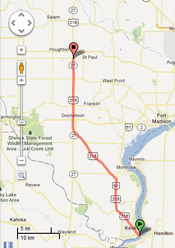
The map below is good for pinpointing Stacie and Rhonda.  The red flag is at 18 miles with RhondaStacie would be just a bit to the southeast of that mark.


I loved the satellite image for Rhonda this week.  A great sunny day in 2009, a cool vapor trail in the sky, and WOW, what a great white convertible.  Seriously, this is the satellite image!  NO HITCHING, RHONDA . . . I don't care how cute the driver might be. ;)


.
 Terry has walked through Donnellson by the end of this week, and is just on the north side of town.  Somewhere just behind him and to the west, just off the highway, is the site of the Lee County Fair grounds expansion. I haven't seen it, but they say the new construction is pretty nice.  He is at 22.9 miles this week. Way to go Terry! Remember folks, he started a week after us and has put the time in to catch up with us all.  The satellite view for him is cloudy, but a nice view of  the turn off towards Franklin--another one of those little villages in the middle of the county.


 For ease in reading, let's map the next few folks all on one map.  Terry's map flag is the red one shown here,  Janet is just past this red flag at county J40 turn off towards West Point. Melinda, if we place her on this map, would be at the very top, where the word Houghton is cut off.  She is at the intersection between Hwy 218 and the Houghton turn off.


The pace mileage for this week was 26.5 miles. Janet managed to get to 26.7 miles, on pace, thanks to a final push on Sunday January 29th itself.  This puts her on the other side of Donnellson, as seen on the map above, at the roughly at the turn off to West Point.  Her view is kinda cloudy, but a cute farmstead in view at least. 


Melinda, Mike and Lucy made incredible progress in week four and are well on their way towards Mt. Pleasant. The road is back to the four lane highway as we caught back up to it on the other side of Donnellson, after our little scenic detour through the center of town.

Melinda has 31 miles to report in week four and a great satellite view of the turnoff towards Houghton.  There's a gas station to the east and the little parking lot on the west is a park and ride area for folks who commute into Burlington together.


Lucy is at 39 miles in week four and has a great view as she is about to cross the bridge over the Skunk River. Yes, this is the same Skunk River we know in central Iowa near Ames. The Skunk River meanders a good 93 miles from its headwaters in Hamilton County, Iowa until it finally joins the Mississippi near Burlington, Iowa.  According to Wikipedia, the Skunk River was known to the Sauk and Fox as "Shecaqua".


Lucy's marker can be seen here, approaching Mt. Pleasant from the south. She has now crossed into Henry County, leaving the Lee County villages far behind her.


Mike has gone on ahead and is through the city of Mt. Pleasant at this point.  He has 48.35 miles at the end of week four.  He has taken Highway 34 out of town headed to the west.  It's a long running argument in my family about whether it is faster to get to Des Moines by taking 218 to Iowa City and then I-80 west, or cutting across Hwy 34 to Ottumwa or such and then north.  We're not in a huge hurry and we want to go to Fairfield, so we're taking the western route, but we will take Business 34 and go through downtown Mt. Pleasant, rather than the norther bypass loop. That saves some steps in the long run. Mike's point on the map is here: 
We'll talk more about the sites we all would see in Mount Pleasant next week, but for now Mike's view is of Highway 34 on the other side of town looks like this. Be warned, there are some mean rolling hills as you take Hwy 34 west  . . . be prepared!

Week Three, Villages of Central Lee County continued . .

On January 22, we ended our third week of walking and are making good progress towards the small city of Donnellson. Progress in week three took us up to and moving past the junction of Highway 218 and 61. We took the west fork onto Hwy 218 to the northwest.  If you were trying to keep up with the pacer, we should end up the week at 20 miles from our start point.  But again, that's just for pacing, most of us are just behind it, and some are just beyond it.

Rhonda is just about to reach the highway fork to start up Hwy 218, here at 8.8 miles from the start.  She will be moving up the road into the villages of central Lee County in the next week.


The middle pack of us are walking through that area now.  This stretch of road takes us through the villages of New Boston and Charleston, Iowa, as seen on Terry's walking map below. 
According to the 1914, History of Lee County, these tiny villages were stations along the Keokuk and Mt. Pleasant branches of the Chicago, Burlington & Quincy Railroad lines. New Boston, in the photo on the left, has a lovely Mennonite church along the highway.
This is what sticks in my head from car trips through the area as a kid. The pretty little white church.

Terry is at 15.3 miles in the third week and just passing to the other side of New Boston, with a beautiful sunny view of the country side heading northwest.


Halfway in between the villages of New Boston and Charleston, we passed the Central Lee School.  This is the county high school for Donnellson, Montrose, Argyle and the county farm kids.  It's a large school for the area and has a large stadium and track for sports. They are the Hawks and Lady Hawks and are a 2A school.  http://www.central-lee.k12.ia.us/high/


Charleston, the next village, I remember, because of the water tower.  It's part of the Rathbun Rural Water Association, which always made me laugh.  The town is less than 20 miles from the Mississippi River to the east, but it still pipes water from Lake Rathbun 60+ miles and four counties to the west. Go figure.


Even though this tiny village is really mostly a collection of houses today,  it did at one time thrive. According to the 1914 History of Lee County:  "Charleston, a town in Charleston Township, was laid out by George Berry on September 23, 1848 . . . . The original plat was 48 small and 3 large lots, with Hackberry, Main, and Elm Streets crossed by numbered streets east and west. Population in 1914 was 65, with 3 churches, public school, post office, express and telegraph offices, telephone connections, a hotel, a general store, and depot." (as quoted from Wikipedia, http://en.wikipedia.org/wiki/Charleston,_Iowa)  The Wikipedia article states that the remaining restaurant in town burned rather spectacularly in 2009.  I haven't driven into SE Iowa recently enough to know if anything has replaced it. Maybe a road trip this summer will tell us for sure.


Melinda, as seen above, is at 18 miles this week. The satellite photo dates to fall 2009--which must have been a good year for the corn. She is just coming up onto the interchange where the new Highway 218 bipasses the old road into Donnellson.


So here is my view (Janet) going under the interchange at 19 miles from start.


The pacer this week would have placed us just beyond this interchange at 20 miles from our start in Keokuk's riverfront park.


The overachievers this week are Mike and Lucy who have blown past the pacer time and moved ahead, again.  Hooray for trail blazers!  They keep my mapping skills moving forward!  
Lucy is at 30.5 miles at the end of week 3, with a view of SE Iowa on a fall cloudy day. The view here shows the turn off to St. Paul, another small village.


 Mike is at 44 miles this week and has actually moved into Henry County and into the eastern neighborhoods of Mount Pleasant.  Again, I am routing him up the old road into town, not the new Highway Bypass. He is now in a pretty residential area.   In the next week, we will hopefully close the gap with him and be closer to entering Mt. Pleasant ourselves.  In the meantime, there are lots of things to do in Mt. Pleasant, so I am sure he can entertain himself while waiting on us.


Wednesday, January 18, 2012

Lee County Villages and Towns


We enter our second week of January working our way through  Lee County, Iowa. 


At the moment we are spread out along Highways 61 and 218.  Let’s look at the county in general as we pass through.  According to the website Iowa pioneers.com:
Lee County is located in the extreme southeast corner of Iowa. With a total of 522 square miles, it is mostly agricultural with the major acreage in farms. The Des Moines River flows southeasterly along the southern border, the Mississippi river flows south along the eastern border and the Skunk River flows southeasterly along part of the northern border of the county. The land along the rivers is forested and steep.  Lee County was first defined in 1836, with the final boundaries established in 1838. Fort Madison was named as the county seat, but due to much disagreement and numerous votes, a second court jurisdiction was established in Keokuk in 1847, and the county seat was divided with deputies at the offices in Keokuk. All land south of the Half‑Breed line, except the east half of Jefferson Township, is recorded at Keokuk, and the remainder of the county at Fort Madison. (The Half-Breed line, also known as Sullivan’s line, is the easterly extension of the Iowa-Missouri border through Lee County.) In 1834, the barracks were built at Fort Des Moines, which was located at what is now Montrose. . .  Land was designated in 1824 for the half‑breeds of the Sac and Fox tribes. In 1838, the lands north of the Half‑Breed Tract were sold by auction at Burlington. Population of Lee county was 2,839 in 1838; in 1850 it was 18,912; in 1860 29,232; in 1905, 18,006; in 1950, 43,102 and in 1990 it was 38, 687”. http://www.iowapioneers.com/County%20Guides/LeeCoGuide.htm
Just as a side note, there are still periodic arguments about consolidating the county capital offices in either Ft. Madison or Keokuk. Neither city wants to give it up, so they continue to share begrudgingly.  This same website listed at least 26 towns in Lee County that once had post offices or sufficient population to make it to the map but are now considered abandoned.  A 1914 History of Lee County Iowa digitized on Google e-books, also remarks:
“Scattered over Lee County are a number of towns and villages some of which are business centers of considerable importance while others are merely small railroad stations, neighborhood trading points or post offices for a given district In the early days of Lee County history there seems to have been a sort of mania for laying off towns, the principal object having been the sale of lots to new comers.  Hawkins Taylor one of Lee County's pioneers in an article published in the Annals of Iowa for October 1870 says ‘Speculation was running high in the spring of 1836 and everybody we met had a town plat.’ . . . In spite of that fact however some of them have survived others have disappeared entirely from the map and it is probable that none of them has come up to the hopes and expectations of the founders.”
History of Lee County, Iowa, by N.C. Roberts and S. Moorehead, The S.J. Clarke Publishing Company, Chicago, 1914.
  
I recognized many of the names on the abandoned list as places that older relatives had referred to, but many were just wide spots in the road as I was growing up in the 1970s. In the last 5 to 10 years, many other towns have lost the highway traffic that provided business to highway gas stations and restaurants.  Both Highway 218 and 61 have had major by-pass work to go around cities such as Donnellson, Keokuk, Fort Madison to the west, and even Mt. Pleasant farther north.  For the dedicated traveler trying to go from point A to point B on a timetable, the by-passes are great. The bypass keeps traffic from having to slow down and gives the locals a break on the incessant truck traffic. For those of us not always in such a hurry who really hate the boredom of interstate highways or who would really like a nice small town cafĂ© or diner, the bypasses take a lot of the charm out of the drive from Keokuk to Iowa City or Ottumwa. 
One such charming place nearly missed on the highway trip along our walking route is Hickory Grove School and cemetery, just outside Keokuk and near our first week pacer mark on the Sandusky Road turn off—about six miles out from our start on the riverfront.   The highway used to pass right next to the school on the west.  The four lane highway now bypasses the school to the east, but it is at least still visible a bit in the distance from the new road.   

 Hickory Grove is a one room school house established in the 19th century. (Photo by Glenn Chatfield at http://schoolhouses.blogspot.com/2011/07/hickory-grove-school-keokuk.html)  The building was, (at least in the 1970s, I don’t know about today), owned by the Keokuk Community School District.  It was a field trip destination for Keokuk grade school students.  As a student, I remember spending a school day at the school house having an “oldey-timey” school experience. We sat in the old desks, wrote with nib pens, did spelling bees and math drills, and took our lunch in tin pails.  I also remember doing a scavenger hunt and gravestone rubbings in the cemetery surrounding the school house. Mom always said I had relatives buried in that cemetery, but I would have to go to her genealogy records to remember which ones. I think it was actually the cousin who had her body stolen . . . but that’s another story for another time.

So where are we this week?  The pacer walk mark has us 13.5 miles out from our starting point in Victory Park.  The pacer is here:


A few folks are ahead of the pacer and a few behind it.  Both are doing ok, it’s just a pacer mark.
 Individually, welcome to Rhonda and Stacie who logged their miles this week!  Welcome also to Rhonda’s husband Terry who has been walking and will have miles entered into the spreadsheet next week.  Elaine, we miss you and hope to have some miles for you on the spreadsheet by next week.  Rhonda is on the north edge of Keokuk, entering the newer shopping areas. 


 At her stopping point this week on the left hand she is at the entrance to the rubber weather-stripping factory where coincidentally my mother worked for nearly 30 years. Seems appropriate that the satellite photo was taken on a grey, gloomy day. 


On the right side is the new Hy-Vee.  Well, new to me anyway. Remember, I’m old.  There was always a Hy-Vee there, but the one I remember was torn down in the 1990s and replaced by a bigger store and Hy-Vee gas station.  The only tragic thing, in my reminiscing opinion, is that they also tore down the old A & W drive in restaurant that used to be on the same lot.  So much for car hops . . .


Stacie is past last week’s pacer mark and through Summitville.  

 The little village itself is currently a mix of old and new houses and a trailer park.  The County Home (senior living at one time for economically challenged individuals) was at one time not far from there as well. Historically,
“SUMMITVILLE The old Town of Summitville is situated in the southwestern part of Montrose Township It is a station on the Keokuk & Mount Pleasant division of the Chicago Burlington & Quincy Railroad eight miles north of Keokuk and twenty miles from Fort Madison It has a general store a money order post office Christian and United Presbyterian churches a public school building and in 1914 had an estimated population of one hundred. “
History of Lee County, Iowa, by N.C. Roberts and S. Moorehead, The S.J. Clarke Publishing Company, Chicago, 1914.

This county atlas listed several Norwegian farmers in the area among other nationalities of settlers.  Tangen wannabes.  I do not believe there are any businesses or churches left in Summitville now, although I could easily be wrong.  The kids attend Keokuk schools by bus, or bus into Central Lee County consolidated school system. There are many quite pretty houses and farmsteads around Summitville, as seen in Stacie’s satellite view.


Melinda was at 14 miles on January 15. 


 She was just about to the point where Highway 61 and 218 diverge. "Two roads diverged in a yellow wood, And sorry I could not travel both And be one traveler, long I stood And looked down one as far as I could To where it bent  . . .” (Robert Frost)  

Highway 61 continues north, down a hill back to the Mississippi River and onto Fort Madison.  At that point, we will be not far off the place where historically the Mormon Trek crossed the ice covered Mississippi River from Nauvoo, Illinois.  Sorry we are that we cannot go down to the river to see that point, but we can’t. We are going northwest in the other direction.  


This week I made it to 16 miles and Lucy was past me at 17.5 miles as seen in her map position above.  We have gone past the highway intersections and are enjoying the Lee County countryside. Her view includes a lovely little rural home:


Mike is still at the head of the pack at 31 miles.  Still not quite to Donnellson, but pretty darn close. We’ll make him take the old road through town rather than the modern four lane bypass around it. We are supposed to be sight-seeing after all.


Thank you Google maps for the satellite images this week.

Tuesday, January 10, 2012

Southeast Iowa in a week's time . . .

Here we are at the end of the first week and the start of our second week of walking.  (Photos unless otherwise marked are from Google Maps Satellite images.) The first week took us through Keokuk.  The hardest incline was from the river to the top of the bluff, then the streets are fairly even and flat through town.   We walked up the Main Street of Keokuk, passing the local shopping mall in sad decline and the two-story 19th century style business buildings that were at one time the heart of town.  A turn at 7th and Main to the right would have taken us into the north side residential district where Janet grew up, but we don’t have that kind of time today.  Most of the shopping district has moved into strip malls and big box style buildings farther away from the river, including the local Farm and Home store/County Market Grocery and the main city water tower.    


Even though we don’t have time to sight see on this trip a right turn just past the stores would have taken us to the high school and then onto Rand Park and a nice overlook of the Mississippi River.  In Rand Park, the statue of Chief Keokuk marks the supposed burial place of Chief Keokuk, a Sauk chief of some note. (photo from http://www.greatriverroad.com/quincy/keokukmonument.htm)


 On the edge of town, past the HyVee and Walmart (ubiquitous in Iowa) are several factories, including a rubber weather stripping factory and a box factory.  Keokuk is actually much more of a factory town than a farming town. 
Main Street becomes the business routes of Highways 61/218. As we head out of town, it’s about a mile to where the street becomes divided highway and gentle rolling hills.  Now we are out into Lee County and see the farms and more rural landscape.  There are many small un-incorporated villages in south Lee County and a turn on a county road just outside of Keokuk would take you to what official maps label as Mooar or Mooar  Station, I believe after an original settler there.  Locals used to call it Powdertown. My mom had told me that it at one time had a gunpowder factory, but that story maybe my own family’s fabrication  If you went the exact 6.5 miles we had intended to walk in the first week, we’ve walked up the highway past several used car dealers  and are at the junction of the highways and Sandusky Road. 

  In the immediate distance is the tiny settlement of trailers and houses known as Summitville.
 
   A turn to the right on Sandusky Road would have taken us to the Keokuk Municipal Airport, a very small air strip and storage hangers and then the few houses that are the little village of Sandusky.  Following that road east and just north along the river you would come to the little village of Galland, site of the very first formal schoolhouse in Iowa built in 1830.  A replica of the building is on the site.

(Photo from  http://freepages.genealogy.rootsweb.ancestry.com/~montrose/Montrose18/gallandschool.htm)

          So where are we now? Lucy, Mike and I had all logged miles in the Google doc spread sheet when I blogged tonight.  I was just past the 6.5 mile mark at 8 miles. Lucy made it to 10 miles So we have walked through Summitville and are in the farmland just past it. 


  Our next milestone will be the intersection where Highway 61 continues down the hill towards Fort Madison and Highway 218 heads  a bit west and north towards Iowa City.  We are taking 218 north to Mount Pleasant. Mike has walked on ahead past this point, don’t worry we’ll catch him.  He’s overachieving this week after a Doctor’s appointment worth of motivation.  Mike has continued up Highway 218.   The rest of us will be hitting this point more or less at the end of this week.  Since Mike is moving ahead, the road takes him onward towards Donnellson.  And so at the end of the week, he is here.